
PhD thesis defense to be held on March 12, 2024, at 17:30 (virtually)
Picture Credit: George Tsavdaridis
Thesis title: Adjustable and Adaptable Systems for Crisis Management Support, Monitoring and Control of Operational Processes
Abstract: In the Section A, in a prior study focused on typical mission scenarios, which encompass intricate operational procedures undertaken by major organizations and political entities, such as search and rescue (S.A.R) missions, medical evacuation (MED.EVAC) operations from border or remote regions, and management of emergencies such as ecological crises or disasters, several key observations were highlighted:
- These missions often involve a significant number of entities and operators.
- Successful execution of missions under complex operational procedures requires various critical information requirements (CIRs).
- Much of this essential information is directly linked to geospatial elements, such as digital terrain maps, transportation networks, administrative boundaries, urban and forested areas, and areas of responsibility (AoR) of units or services. Moreover, indirect geospatial connections exist with factors like legislation, international guidelines, and regulations governing the movement of people and goods in urban areas, ports, maritime spaces, and territorial or international waters.
- Effective communication and coordination among involved entities, actors, and operators are crucial in all aforementioned missions.
Given these necessities, there is a demand for designing Specialized Computational Monitoring and Control Systems. These systems must adequately address the aforementioned requirements and aid operational officers in making informed decisions, while also assisting operators in executing their missions proficiently. When such systems are geared towards managing significant emergency incidents or situations, they are often referred to as Crisis Management Support Systems. These systems receive support from international, national, and/or private entities, which play a significant role in developing, maintaining, and updating a multitude of geospatially correlated data.
As is evident, these Support Systems inherently entail significant complexity and high costs due to the intricate nature of the missions they support. Practical observations have revealed that without specialized and rigorous design, the core data and programs of these Systems may encounter:
a. Significant, possibly decisive, challenges regarding the diversity and interoperability of internally organized data.
b. Specific difficulties in updating and relevantly upgrading their content.
These challenges stem primarily from the large volume, multifaceted nature, and complexity of the data these Systems utilize. The prevailing solution has been to limit the scope and extent of each Support System to ensure controllability and functionality. However, such systems often employ an 'ad hoc' internal architecture, tailored on a case-by-case basis, rendering it non-transferable to similar applications.
Given these difficulties and associated problems, there's an imperative to explore the construction of a generic Monitoring and Control System. This system, with suitable parameterization and configuration (and minimal additional programming), could effectively support complex missions as they arise. Through collaborative efforts with operational officers and officials, it has been established in this Doctoral Thesis that abstracting a design for a configurable and parameterizable generic core is indeed feasible and desirable.
A pilot development was initiated to illustrate the specific issues addressed in this research and doctoral thesis, focusing on a typical, generalizable, and complex mission involving numerous Public and Private Entities. The design of this mission was conducted using the "Military Decision-Making Process - MDMP" methodology, recognized as the most advanced planning procedure for such purposes. The mission was segmented appropriately to facilitate functional and operational ease.
In the subsequent phase, two (2) Special Innovative Action Flow Diagrams were developed. It's important to note that there have been no corresponding descriptions thus far that sufficiently elaborate and support the intricate procedures of composite missions examined in this Doctoral Thesis.
The first Diagram outlines the Operational Planning Algorithm of the Warning Order (WARNO), involving a substantial number of Operators transitioning from a state of calmness to the highest operational readiness state. The second Diagram focuses on the Operational Functioning Algorithm of Transport Missions, specifically applied within the framework of this Doctoral Thesis for a specific complex mission, across each segment of its course.
These Special Innovative Action Flow Diagrams aim to demonstrate that any operational procedures executed by relevant Operators in the missions scrutinized in this Doctoral Thesis (and beyond) can be more comprehensively and accurately described using common algorithmic action segments. These segments, though relatively simple, are highly applicable.
Subsequently, all autonomous segments of the examined complex mission were detailed using the aforementioned Special Innovative Action Flow Diagrams. It's noteworthy that these Diagrams are particularly conducive to human understanding. They were developed using the free yEd software by yWorks, designed for processing and visualizing graphs using the GraphML graph description language (a type of XML). The choice of GraphML allows for a readable and manageable format, with the added capability of being computer parsable. The yEd Diagram can automatically transform the GraphML graph into the Diagram (back-annotation), maintaining the Diagram's geometry. Additionally, the GraphML code enables the inclusion of supplementary information and references to external sources, as well as the internal encapsulation of datasets (which may refer to external databases).
The preferred approach was to comprehensively describe the proposed diagrams to optimize their operational functionality practically. The method employed was horizontal work, aiming to enrich the diagram's description to illustrate both its particulars and its specific suitability for its intended purpose.
The detailed examination of the aforementioned diagrammatic algorithms culminated in the creation of two (2) innovative and broadly applicable Flowcharts. These Flowcharts, easily comprehensible to the human mind, are capable of supporting various types of complex missions. This generalization emerged from the detailed analysis of the two (2) Special Innovative Flowcharts (WARNO algorithm and transport missions), allowing for the preconstruction of generalized segments to describe complex missions, owing to the fundamental similarities observed in operational procedures among different complex missions.
While delineating the proposed diagrams, the necessity of managing accompanying information was recognized, which exhibits diversity and, in certain instances, considerable complexity and potential polymorphism. All aforementioned elements necessitate specialized handling. Within this study, emphasis was placed on the detailed description of the differing nature of information associated with each node or edge of the diagram. This differentiation of information is typically attributed to:
a. Varying analysis or granularity (small or large) of information (Resolution or Level-of-Detail, LoD) required by the Actor participating in a complex mission. This analysis must be extensive when specialization is needed and may be minimal when the required information is of a general nature.
b. Differing Extent of Visibility (Extent of Visibility – EoV) of the Actors in the Diagram. Each Actor possesses a different visibility range, both horizontally and vertically. Specifically, an Actor, such as an 'Operations Center,' enjoys maximum visibility among all Actors in the mission.
The aforementioned assertions arose from presenting detailed indicative examples of necessary accompanying information (common and specialized, etc.) that can be attached to the Flowchart Description Diagram. These examples involved extensive analysis of the varying nature and the expected substantial volume of required information associated with each node or edge of the diagram.
The entire study focused on methodological approaches to minimize the information conveyed to each Actor in the Diagram, aiming to avoid the risk of Information Overloading. The findings are as follows:
a. The necessary information may be associated with different Actors (simple or complex) and can be provided to them in a predetermined manner or upon their request (on demand).
b. There is a possibility of providing common segments of necessary information to different Actors.
c. When information is transmitted from an Actor to a sub-Actor at lower operational level(s), the sub-Actor can update and modify this information and return the updated information solely to the Actor who initially sent it.
d. There exists the capability to access all information related to Actors and sub-Actors serving common actions or sub-actions.
A primary observation from the study of the information attached to the diagram revealed the necessity of having Supporting Data and Information Structures, which are essential and critical for the correct functioning of the description of pilot, composite operational procedures, and missions. A second crucial observation was the indication of the need for an Accompanying Information System capable of managing the vast amount of data introduced into the Special Innovative Flowcharts.
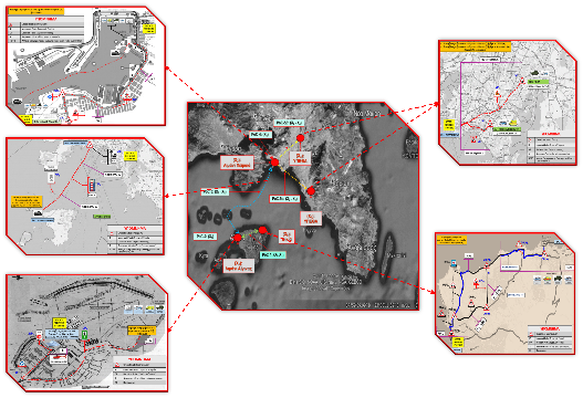
Moreover, extensive research trials known as Proof of Concepts (PoCs) were conducted, serving as essentially realistic tests that functioned as demonstrations, descriptions, and physical control (Dry-Run) of the Flowchart Algorithm of Transfer. Specifically, the following Research Trials were undertaken:
a. PoC-1: focusing on the movement of vehicles and officials from home to the entrance of the New Aegina port (X0 - X1).
b. PoC-2: concerning the movement of vehicles and officials within the New Aegina port (X1).
c. PoC-3: involving movement at sea from the Aegina port to the Piraeus port (X1-X2).
d. PoC-4: addressing the movement of vehicles and officials within the Piraeus port (X2).
e. PoC-5α: detailing the movement of the ambulance (with the patient official) and the police vehicle from the Piraeus port to the Tzaneio Hospital (X2-X3).
f. PoC-5β: focusing on the movement of the military vehicle (escort) and the police vehicle from the Piraeus port to the Ministry of Defense (X2-X4).
These PoCs showcased the feasibility of developing support programs for an ad hoc mission in practical scenarios. It's noteworthy that significant emphasis was placed on the strict and exhaustive description of autonomous segments of the pilot composite mission in the form of diagrams. These diagrams, comprising a set of processes (parallel, sequential, serial, etc.), are easily understandable by the human mind and are machine-readable as they were developed in GraphML format. The PoCs confirmed that the Special Innovative Flowcharts are capable of effectively describing all actions/processes at every point of the complex mission independently, without necessarily requiring the generation of code.
During the Research Trials, four (4) Special Critical Supporting Computational Structures (both primary and auxiliary) emerged, addressing:
a. The prediction of immediate (future) spatial transitions and associated actions of the Actors.
b. The comprehensive recording of all actions (history) undertaken by the Actors from the initiation of the transfer mission to the current time point of the Diagram.
c. The current transportation Segment depicted in Chapter 7.
d. The present Decision Point (DP) identified in Chapter 7.Through the utilization of PoCs, it became evident that in most pertinent Systems utilized for Monitoring and Controlling Operational Procedures (and consequently for Crisis Management Support), there are similarly structured sub-sections and a shared core of actions, which:
a. Are standardized and
b. Potentially pre-designed, manufactured, and programmed,
to form a collection of adaptable and adjustable tools for the swift and effective deployment of Systems for Monitoring and Controlling Operational Procedures. Consequently, it was determined that the development of a Mission Support Information System for Complex Operational Procedures is indeed feasible. Furthermore, a pioneering methodology for implementing systems and data architecture, known as Teleological Organization, has been explored, already applied in other research and development domains encountering similar complexity and data volume. A notable instance is the construction of the European Transport Policy Information System (ETIS), which has yielded commendable results.
This architecture is founded upon the development and utilization of a specialized thematic metadata framework known as the Teleological Structure, also referred to as the System Content Map. This structure serves as the primary axis for the efficient organization and effective utilization of individual data and programs within the proposed Information System. Consequently, it ensures easy manageability, upgradability, scalability, adaptability, and ultimately, heightened efficiency. It's worth noting that this Teleological Organization can be leveraged to construct associated Design, Simulation, and Monitoring Systems (DSM) for Complex Operational Procedures. Unlike chaotic information dissemination, the transmission of information to intended recipients is guided and controlled by the specific purposes for which the individual information sets were generated.
In the context of this study, as previously mentioned, various approaches for addressing challenges stemming from complexity, diversity, and the sheer volume of data required for the operation of the Information System (IS) were proposed to mitigate the effects of Information Overload. These resolution methods are intricately connected to the Teleological Organization as outlined below:
a. Differentiation of the type of information associated with each node or edge of the diagram follows a purpose-based and necessity-based approach for each actor involved, which may vary between common and specialized actors. Further differentiation is carried out based on:
i. Varied analysis or detail resolution required by participating actors in the examined complex mission, termed as Resolution or Level-of-Detail (LoD).
ii. Diverse extent of visibility among the diagram's actors, referred to as Extent of Visibility (EoV).
b. Special Accompanying Boxes containing critical information or data are strategically positioned at various points within the proposed Special Innovative Action Flow Diagrams, essential for executing specific actions or processes.
Consequently, numerous subsets of data, varying in size from small to large, have been generated with specific resolution and scope. This approach enables actors to access only the subsets pertinent to their roles, thereby substantially reducing the complexity arising from the differentiation of essential information associated with each node or edge of the diagram.
c. Each actor was empowered with the capability to update or relay information available to them, ensuring that they could transmit these updates exclusively to the originating superior or head actor.
Consequently, this method effectively reduced the volume of essential information associated with each node or edge of the diagram.
d. The integration of the Decision Support System with external systems was facilitated through a specialized Information Request process known as Request for Information (RFI).
In summary, concerning Crisis Management Support and Monitoring and Control Systems of Operational Procedures, it has been established that it is feasible to:
a. Establish a common, adaptable (according to mission requirements), and pre-programmed core of programs and data, which, with the addition of necessary software, can:
(1) Facilitate the management of multiple complex missions.
(2) Significantly reduce the construction costs associated with developing the requisite Information System for each mission.
b. Tackle Information Overload resulting from the complexity, diversity, and volume of data within an Information System (IS) in a specialized manner. This involves preventing actors from being overwhelmed by restricting the provision of information to only what is pertinent and necessary (the principle of need-to-know).
c. Create a Special Accompanying Critical Computational Structure for managing information linked to the diagram. This structure will be based on the Teleological Database, organized in a specialized and systematic manner according to the purposes for which individual sets of information were attached to the diagram.
In the Section B, the objective was to determine, with a high degree of certainty, whether a handwritten document obtained from the Army History Directorate (AHD) belonged to Eleftherios K. Venizelos. The process of identifying the author of this historical document, which lacked a signature, involved comparing it to the handwriting style found in official documents from the Eleftherios K. Venizelos National Foundation in Crete. This comparison utilized photographs of authentic texts associated with this significant figure, captured at high resolution. The verification process employed algorithms for semi-automatic supervised letter extraction, along with algorithmic schemes for automatic image segmentation, specifically on images containing isolated letters from the aforementioned texts. The research outcomes indicated a strong likelihood that the document housed at the Army History Directorate was indeed handwritten by the renowned Greek politician Eleftherios K. Venizelos. In conclusion, based on these findings, it is highly suggested that both texts were authored by Eleftherios Venizelos.
Supervisor: (Retired) Professor Konstantinos Papaodyssefs
PhD Student: Georgios Tsavdaridis